 Gaia 3 accessing EPA's WFS and combining it with imagery from Microsoft Virtual Earth and user-generated geospatial notes
There’s been a lot of whining lately about the “failing” state of spatial data infrastructures (SDIs). Don’t give in to pessimism - because it’s just not true. Let’s take a look at what an SDI really is and discuss some examples of why we’re blessed to be living in the Golden Age of SDIs.
What’s an SDI?
Well, the US government defines an SDI as the “consistent means to share geographic data among all users.” They go on to describe an SDI as the “the technology, policies, criteria, standards and people necessary to promote geospatial data sharing throughout all levels of government, the private and non-profit sectors, and academia. It provides a base or structure of practices and relationships among data producers and users that facilitates data sharing and use. It is a set of actions and new ways of accessing, sharing and using geographic data that enables far more comprehensive analysis of data to help decision-makers chose the best course(s) of action.”
Policy-powered data
Policy is the key element of SDIs. This probably hurts the feelings of folks that like to talk about WMS, WFS, clients and catalogs – but it doesn’t make it less true. Policies that promote data sharing are sometimes hard to pinpoint but some great examples of successful policies that “promote sharing of geospatial data throughout all levels of government, the private and non-profit sectors, and the academic community” can be found behind today’s most popular platforms like Microsoft Virtual Earth, Yahoo! Maps, Google Earth and others.
If you are looking for policy successes - you need look no further than the US government’s policies towards satellite imagery. Specifically, the Land Remote Sensing Policy Act of 1992 opened the door for private ownership of American imagery satellites and ushered in the beginning of the golden age of SDIs. In 1994, the Clinton administration built on this policy by issuing additional guidelines for licensing commercial high-resolution imagery satellite operations. In April 2003, the Bush administration announced a new policy that makes commercial satellite imagery the primary source for US government users, instead of imagery taken by government satellites.
The net effect of these policies has been a massive shift to more democratic access to satellite imagery - powering government services, many of today’s most popular mapping platforms including Microsoft Virtual Earth, Yahoo! Maps, Google Earth and cutting-edge new applications like ((Echo))MyPlace. Is this type of data the only source that matters? No, but take it out of the major platforms and I’ll bet you see a lot of big white, empty rectangles.
At this point, some folks might be tempted to say, “Microsoft Virtual Earth, Yahoo! Maps and Google Earth aren't part of SDIs!” My response is – what makes you say that? They certainly count as “new ways of accessing, sharing and using geographic data” and government agencies are most certainly embracing them. Plus, much of the underlying data comes from sound policy.
Another key example of policy-powered SDI success is NC OneMap. The heart of NCOneMap is innovative partnerships between municipal, county, regional, state, federal agencies, private industry, and other organizations that create and maintain geospatial data layers for some aspect of North Carolina. Each partner serves their data in an OGC Web Map Service (WMS) and layers are available for use in map viewer applications like Gaia 3 and others. The key policy vehicle here is the "Cooperative Agreement" - used to ensure that the geographic information infrastructure endures and continues to meet user needs.
Citizen-powered SDI
Of course, there’s work still to be done. In my opinion, advancing policies that leverage the Internet's ability to empower citizens to participate in SDI’s is both the greatest policy challenge and opportunity. Probably the greatest challenge is creating an environment among all levels of government that allows self-organizing social networks to create and share user-generated location content. This process is well underway on the Web but it’s likely to meet some resistance from traditional “GIS database” thinking that may not readily accept the idea that loosely coupled networks of content providers can deliver “good data” for SDIs.
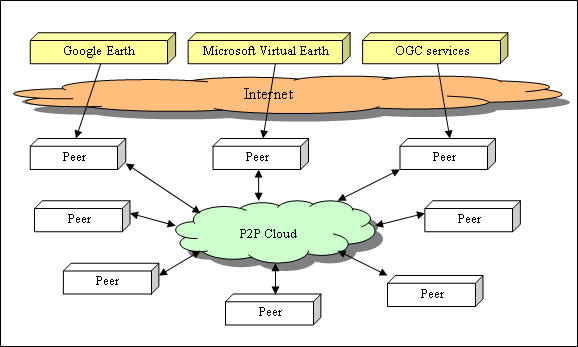
Providing incentives to create content channels where trusted networks of users share user-generated location content under the legal banner of cooperative agreements could help mitigate this challenge. I’d also recommend promoting the development of trusted community-based content networks that allow exchange of location content through partnerships between municipal, county, regional, state, federal agencies, private industry, citizens and other organizations that create and maintain location content for specific areas. Combining newpolicies with technologies like the CarbonCloud P2P framework opens up many new potentials for SDIs.
So don’t give in to pessimism - we’re blessed to be living in the Golden Age of SDIs
Future posts will address the availability of clients and WFS…