Geospatial Collaboration and Interoperability Goes Mobile
In today's world knowledge about the Earth and the activities on it rarely comes from one source, and it's constantly changing. For example, Army units may transfer in and out of areas. Military personnel need to work in collaboration with coalition partners and non-governmental organizations. In addition, there are growing geospatial crowd-sourcing communities adding updates every day. In this environment a new generation of interoperability and collaboration is vital. But current mobile apps for geospatial intelligence (GEOINT) are often 'stovepiped' - in other words they often work with one vendor or online service only, and usually store geospatial data centrally. What's needed are easy-to-use, interoperable mobile geo-apps that put the power of GEOINT into the hands of users. With these geo-apps users can connect to dynamic data networks and create a sharable geospatial foundation in real time.
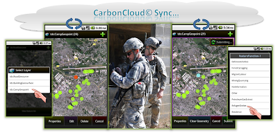
Here at The Carbon Project we've been working on this challenge and rolling out a new generation of CarbonCloud Sync Android apps built on standards from the Open Geospatial Consortium, Inc. (OGC). These geo-apps support collaborative, dynamic geosocial networking - and enable information and updates to be shared enterprise to enterprise, vertically and horizontally, and from tactical to national levels in real time. Enterprises also have the ability to 'plug-and-play' with any standards-based data service in seconds (via OGC WFS) and manage communities of users as information and collaboration needs change.
With these easy-to-use apps enterprises can get answers to critical questions, including:
- Where are the refugees; where do we need to send relief supplies?
- Where is the damage? Where should we send our rescue teams?
- Is the road open? And for how long?
- Can I see just the updates for next week over this hotspot?
CarbonCloud Sync mobile apps help by allowing enterprises to receive geospatial updates from many sources, validating them if needed, and then instantly sharing them with the people that need them. With this new capability enterprises gain the power of mobile geosocial networking and interoperability - and needed insight about our rapidly changing world.
- Jeff
GEOINT data services shown above provided by CubeWerx WFS


