CarbonCloud®
Thoughts on Geosocial Networking®, cloud computing and democratic access
Friday, April 11, 2008
Tuesday, April 08, 2008
Polar ice shelves break off - OGC SDI 1.0 powers up

In late February 2008, the Wilkins Ice Shelf on the Antarctic Peninsula disintegrated, an indication of warming temperatures in the region. This dramatic event was captured on satellite imagery and a British Antarctic Survey's reconnaissance flight last month - shown above in Gaia 3.1.
Now researchers have a another tool in the climate change battle - the National Snow and Ice Data Center's "Atlas of the Cryosphere" OGC SDI 1.0 services.
We've been testing these OGC web services and are impressed by both the data and unique polar perspective - great job by the developers.
The Cryosphere Atlas lets people explore and dynamically map the Earth's frozen regions. Viewed from a polar perspective, data sources include snow cover, sea ice extent and concentration, glaciers, ice sheets, permafrost and other components of the Earth's cryosphere.
Users can zoom in to a specific region on the Earth as well as overlay country borders, major cities, and other information - an example in Gaia 3.1 is shown above. Gaia 3.1 was developed under the NSDI CAP.
Thursday, April 03, 2008
UK Hydrographic Office Purchases CarbonArc PRO for OGC Development
 The Carbon Project is pleased to announce that the United Kingdom Hydrographic Office’s Defence Development Group has purchased CarbonArc PRO for ArcGIS 9.2 to support its OGC development work.
CarbonArc PRO brings a new generation of Open Geospatial Consortium, Inc. (OGC) data discovery and production tools directly to the ArcGIS 9.2 desktop.
Wednesday, April 02, 2008
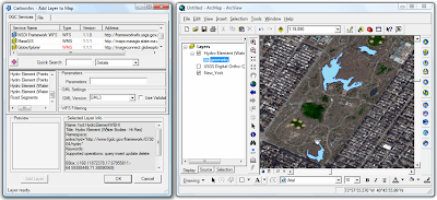
Adding GML features from WFS to ArcMap - easy as a walk in Central Park

People have been contacting us lately about how they can use WFS in ArcMap. Here's an example -
Select the NSDI Framework WFS, change the GML version to GML3 and click on the Hydro Element (Water Bodies - Hi Res) layer. Once the preview is generated add the feature layer to the map. Note that you can alter the polygon styling the same way its done for any other features in ArcMap (CarbonArc uses the native ArcMap symbology in order to render the GML features).
A quick way to alter the symbol is to click on the symbol legend in the layers list. Once the symbol is selected the layer style will be automatically updated.
The following companies provided software or OGC SDI services used in this example - USGS, ESRI, CubeWerx, Digital Globe and geoLeaders.
- Jeff
Matching a place to a geoname - GML labeling in CarbonArc PRO

We've been testing some Gazetteer WFS this week - and one of my new favorite features in CarbonArc PRO 1.5 is the GML Labeling.
This function allows simple labeling to be added to GML layers. To set the labeling, all I do is select the name of the GML property to be displayed, the label symbol and style of the Text Symbol.
You can create a display like the one above in about 15 seconds.
The following companies provided software or OGC SDI services used in this example - USGS, ESRI, CubeWerx and geoLeaders.
- Jeff


